Charting Islands / Campaign Diary: Archipelago Adventures - Pt. 4
Last week we left off on creating a Navigator for our ship, and now we have to take their abilities and put them to use. My original idea for figuring out islands and encounters is going to be using a hex crawl system. This system will involve a good bit of rolling (yay!) or the GM can simply decide to just pick and choose from a predesignated list (or a mixture of both options). This will keep things exciting for not just our players, but our GM who will be experiencing these surprises as well!
Hex Crawl
Before we go any further, let’s talk about Hex Crawls first. For those that aren’t aware, a Hex Crawl is: a map provided to the players with grid of hexes across it. It is up to the players to explore through the hexes and to uncover the map for themselves and the GMs have several Point of Interests (PoI) spread throughout the map for the players to uncover.
For my original idea of the adventure, this hex crawl will also be a source of unknown for the GMs and so those Point of Interests will be determined by the players. When the players leave their island, they will roll their Navigation check to determine where the next island is and, if they so choose, can make progress towards that location. To do that, we are going to make a simple hex map that I’ll draw up real quick in Inkarnate.
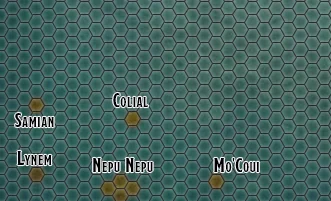
Luckily for us, Inkarnate starts with just pure ocean on the map, and then you get to add in some land. For us, we are going to keep it pretty empty. It’s a bit hard to see, but there are small hexes all over the map, and for each of those hexes, they are considered undiscovered. But, our table is starting on a discovered island, along with a few other islands that I assume the natives would know about, so lets add those in!
That’s better. Now we got some land masses on there (in case you missed it, look at the bottom left and squint). We are going to keep with simple shapes for our big island map and just fill in the whole hex if there is an island located somewhere. When we get to creating our individual islands we will give them more shape then.
Nepu-Nepu
Now, we have our hex map, let’s go ahead and name a few islands just so we can talk a bit more specific, and then we can really get into the meat of this post.
Starting with our largest: Nepu-Nepu, so good they named it twice, (before you ask… No, I’m never stopping) this will be the first island that the party will find themselves on when it is attacked by the evil horde of hobgoblins and goblins.
This will be a great starting point as we can have our party do a few small adventures on the island to get them acquainted with our story and culture we will be building. Plus, if they make any friends on the island they will be even more distraught when the horde comes and maims/kills/captures that person.
Before I get any more distracted by adventures, let’s turn to the nitty gritty and assume that our navigator is on Nepu-Nepu and wants to get to Colial. Now, Colial is a known island and they can point to it on a map that someone is keeping. They will pile into their ship and begin journeying to Colial. Because we are trying to make this simple in our example, we will say that 1 hex is 1 full day of travel. From what we can see, they will be on the ocean for 4 days and arrive on Colial on the 5th day.
What our Navigator will need to roll is the Navigation/Survival check at the end of each day to make progress to Colial, because they know where they are going and they have a map, the DC will be pretty low, let’s say DC 10.
Our Navigator will make 4 Navigation/Survival checks for each day they are at sea, and we will assume that on the 5th day, they find Colial and they don’t need to make a Navigation/Survival check. Now, obviously we are skipping through a few things like random encounters or RPing just for the sake of brevity. If our Navigator makes all their checks, they easily arrive at Colial and they are not lost.
But if they do get lost, how do we figure it out? Well, we will be coming up with rules for getting lost in a later post, for now let’s just assume that our Navigator did their job and everyone arrives at Colial in one piece.
Now, let’s say that our party wants to head out into unknown territory, let’s go ahead and put a fog of war over the undiscovered islands. I’ll go ahead and put a parchment color over our unmapped archipelago and just reveal what the party has found so far.
Whew, that’s a lot to discover for our party, but for our basic example, it’ll work well for us. So, let’s say that down on Colial, our Navigator wants to figure out where the next island is that they haven’t found yet. We are going to use a chart to figure out where our next island is. First, our Navigator will spend a day studying the stars, the ocean currents, the winds and several other factors. They will then roll their Navigation check. Let’s say they get a 12.
Now, what do we do with that 12? We are going to build a chart for them to roll off of!
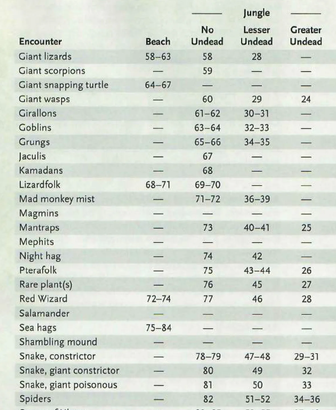
Tomb of Annihilation - small part of the Hex Crawl chart
I’m going to try and make our chart in a similar nature to the big chart in Tomb of Annihilation. A single chart that has everything on it that we will ever need to roll on. While I already know that that isn’t true, we are going to come at this from a place of simplicity and ease of use.
To further that purpose, we will have 5 columns going across our chart: Island Coordinates, Check 1-6, Check 7-12, Check 13-18, Check 19+. The check number is based off of a range of 6 digits each that gives us a pretty good range. I’ll admit I just picked a random range to go with, though I like it.
Now our columns are decided, but what are we going to put in them? Well, let’s start with our checks. In Tomb of Annihilation, they have the d100 roll you need for in the center of the chart, so our Check columns will have what d100 roll you need to get to figure out your Island Coordinates. Our island coordinates will be a series of rolls for either the DM or the Navigator to roll. I’m not sure which would be better to be honest.
I went into GM Binder and put together a rough chart for us to work with. I wish I could say how I figured out the numbers, but I just put in what felt right. I’ll try my best to explain it all.
My thinking with this chart is that a positive result would mean that the party doesn’t have a long way to travel and that the next island will be pretty close. I increased the chance for each Island Coordinate that had a larger sized coordinate dice to a maximum of 5 and for our higher checks, made the average d100 roll (51) to have a smaller coordinate dice. A check of 1-6 will have an average distance of a d11, while a check of 19+ will have a d7.
So when you roll for your Survival check (we said 12 for our Navigator) we would look for our Check number (2nd column, Check 7-12). Now, we must roll a d100, I rolled a 38. That puts us at N-d9, E-d9. Now, what does that mean? It means we are going to roll a d10 to determine how many days to the North they travel, and roll a d10 to figure out how many days to the East they must travel. These rolls will determine where our next island is in relation to our party.
I expect that me saying we roll a d10 when it is a d9 is pretty confusing, especially since a d9 doesn’t exist. I elected to put all odd dice numbers in there so that I can put in this note:
When you roll for your Island Coordinates, you will see that there are odd number dice for the roll (i.e. d3). This means that you will roll a die that is one number higher than that die (d3 + 1 = d4). On the result of the highest number, in this case a 4, that means that you will travel 0 days in that direction.
Example: N-d3, E-d3 -> I will roll 2d4. The first d4 will be for the number of days traveling to the North, the second d4 will be for the number of days traveling to the East. I roll a 4 and 2. This means I will travel 0 days to the North, because it is the highest result on a d4, and I will travel 2 days to the East to find the next island.
I realize that that might be confusing at first, but it seemed like the simplest way of adding in a 0 to the number of days traveled, though maybe you could add in something like minus 1 from all die rolls… but that seems obnoxious. Feel free to tell me that my idea is rubbish, and I may change it later on.
Forward!
So, we determined that our next island to find is to the North d9 days and to the East d9 days. Let’s go ahead and roll 2d10 (and remember that a value of 10 means that you travel 0 days in that direction). Using my d10 dice, I get an 8 for the first value and 3 for the second dice. Our party will travel 8 days to the North, and 3 Days to the East to find their next island. I expect that most will go in a diagonal line, but you should allow your players to tell you which squares they move through to reach their newly discovered island. And remember, this is the island that the navigator found, they aren’t required to journey there if they don’t want too.
In this map, we can see that I chose my direction to the newly chartered island, but I could’ve taken any approach to that island by just randomly going across hexes. For each hex that the party goes across, you will roll for random encounters that may even include finding more islands that the Navigator missed in their check! Islands in this adventure aren’t predetermined. There is a very slim chance they may find more than one island on the way to their original island.
But what if we have a problem. Like say we are on Colial and we roll that an island is to our South… Well, thankfully there is a smart and quite handsome GM at the table and you would just reroll on the appropriate Check column till you get a result that would be appropriate for your party depending where they have discovered past islands. Or you can change the direction from South to North if you want. Or tell the Navigator that they failed their check for the day and they need to spend another day locating an island. It’s all up to you! The GM is going to be used to double check the distance of everything to ensure that islands are appearing in already discovered oceans as that would be ridiculous (but that gives me a great idea for an island).
And this is where we are going to stop for this week. I have the rough outline of how the island exploration system will work and I’m pretty pleased with it. Next week we will discuss more about how exploring the archipelago will work and then we will change things up and discuss our story a bit more now that we have our system going.
Follow us on Twitter to keep up to date on everything we talk about!


